
 |
Archaeology in Baden-Württemberg |
| Excavations at the Deserted Medieval Village of Vöhingen | |
Roads |
|
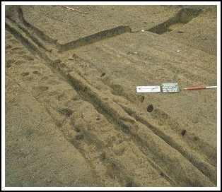 |
From field-names and boundaries on the
oldest boundary map (1830 ?) knowledge can be gained of the road
system in and around Vöhingen. Archaeological excavation
reveals this to have consisted mostly of hollow ways, whose depth
indicates long use. The south wall of the graveyard apparently
collapsed several times into the hollow way directly outside of it,
and had to be repaired repeatedly. The north-south running "Vöhinger Graben" (literally "Vöhingen Ditch", indicating the state of the hollow way) was also consolidated in part by the building of a small wall. Where no buildings prevented it, the tracks could in time reach considerable widths, as is demonstrated by the 20 m wide stretch in the northeast of the excavated area. |